Category Archives: Hackett Blvd Building

Late Autumn 1965 — Construction Continues on Hackett Boulevard

Today we share the last three photographs showing construction of St. Paul’s Hackett Boulevard building. These slides were processed in November 1965, and probably show progress as of late October or early November of that year.

The first photo is from an unusual vantage: the photographer stood behind and above the chapel, providing an interesting view of parts of the surrounding area. You can clearly see that what is now the Albany Medical Center South Clinical Campus parking lot was still open ground.

Hackett Boulevard November 1965

Hackett Boulevard November 1965

The second photo shows the west end of the nave, with all exterior work apparently complete.

Hackett Boulevard November 1965

Hackett Boulevard November 1965

And finally, another shot from the east, showing the back of the education wing and the back of the church proper, with the back wall still not enclosed. You can just make out workmen, sitting on scaffolding.

Hackett Boulevard November 1965

Hackett Boulevard November 1965

These are the last photographs showing exterior construction. Work on the interior must have continued through the winter, in preparation for the consecration of the main altar in April 1966 and  consecration of the entire building in June of that year.


Early Autumn 1965 — Construction Continues on Hackett Boulevard

Here is another set of slides showing construction of the church on Hackett Boulevard. These were processed in October 1965, and so they probably represent the situation in September or early October of that year.

It is striking how similar the construction looks to the view from slides processed in early spring of that year. One parishioner remembers hearing that a strike virtually stopped work for several months, and that may explain the slow progress.

Hackett Boulevard Choir Room and Church, October 1965

Hackett Boulevard Choir Room and Church, October 1965

Hackett Boulevard Church, October 1965

Hackett Boulevard Church, October 1965

Hackett Boulevard Choir Room, Parish Hall and Church, October 1965

Hackett Boulevard Choir Room, Parish Hall and Church, October 1965

Hackett Boulevard Church, October 1965

Hackett Boulevard Church, October 1965

Hackett Boulevard — The Lay of the Land

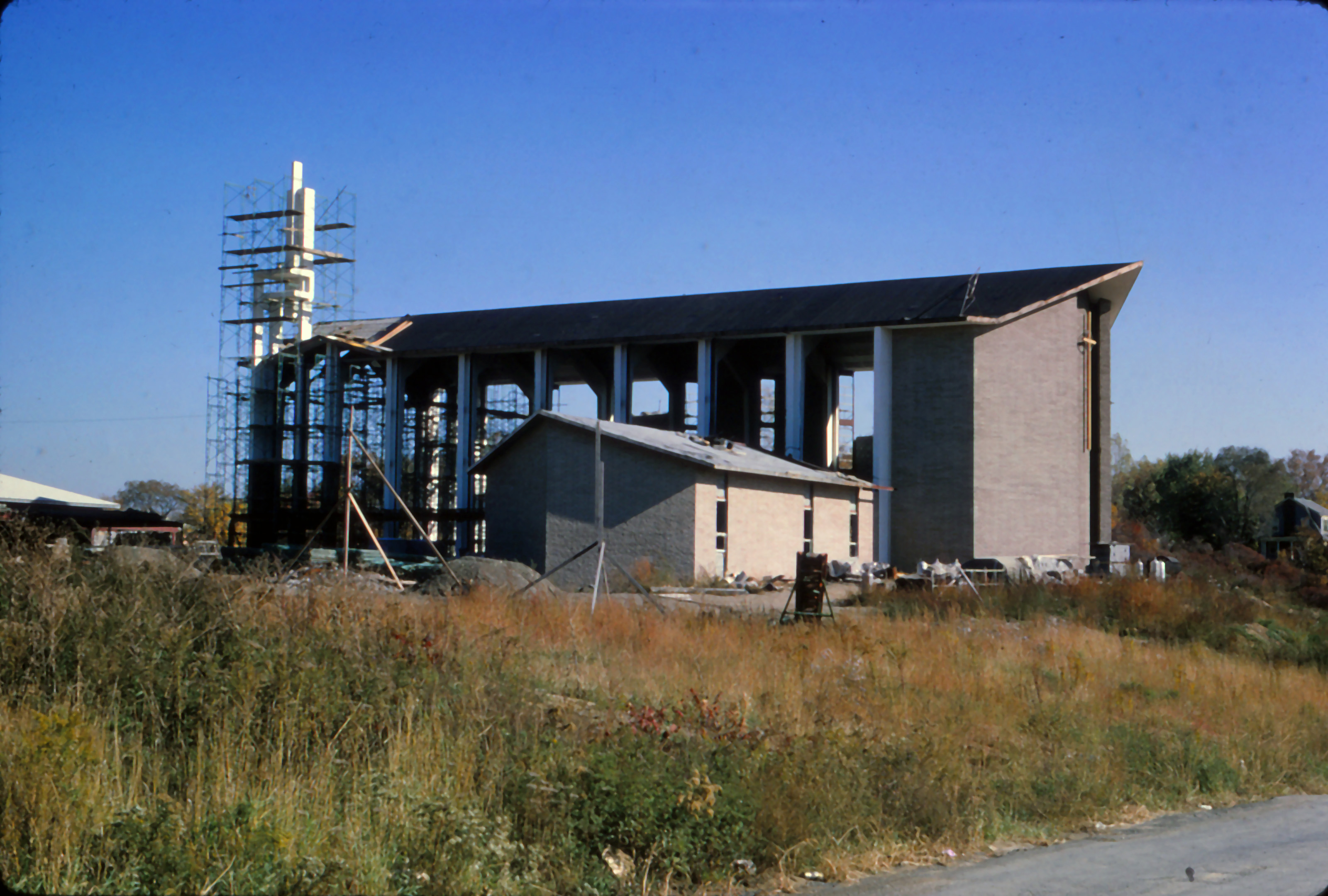
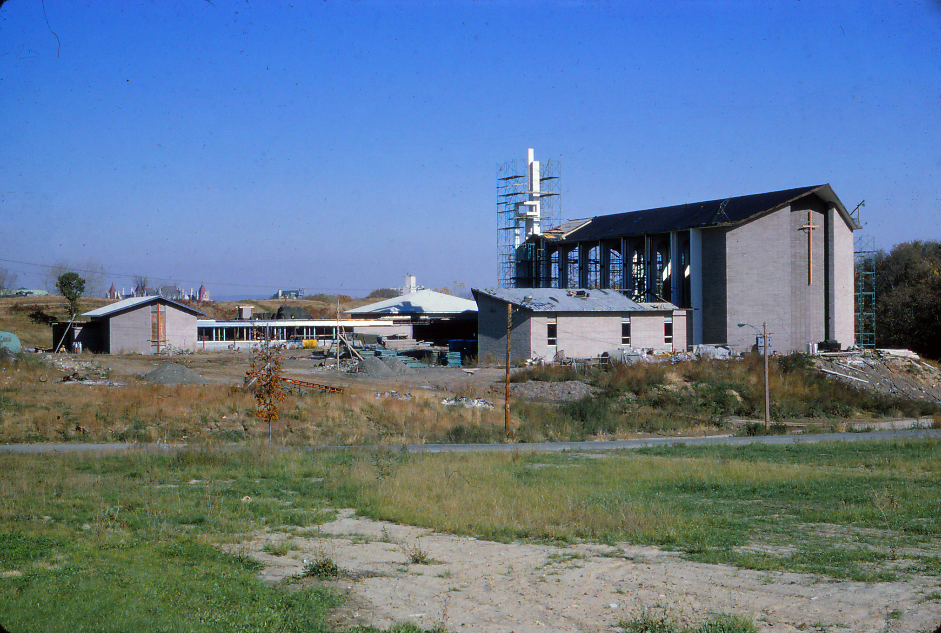
Approaching St. Paul’s Church on Hackett Boulevard, the building presents an impressive, but not particularly friendly, aspectHackett Blvd. building seen from west. Whether one is coming from the west


or from the east,churchonhill-190


the church rises fortress-like above the street, its massive walls showing no clear inviting entryway. IMG_8157

It is only when the driver turns into the parking lot from Samaritan Road that the  building opens, and the visitor is invited to enter. IMG_8191 v002

The building turns its back to the street; its entrance faces the buildings to its north, the buildings that originally composed the Episcopal diocese’s Good Samaritan Center: Child’s Hospital, Nelson House and St. Margaret’s Home. St. Paul’s, which it was hoped would become the chapel for these institutions, faces and invites those that it serves.

This explains the orientation of the building. but how did the church building come to be placed so high above the roadway? To answer this question, we first need to understand that in the mid-1950s the eastern section of Hackett Boulevard was unpaved, and reached only from Holland Avenue to what is now Samaritan Drive, where it angled northward to provide access to St. Margaret’s Home.

1953 topographic map of Albany's University Heights section (credit andyarthur.org)

1953 topographic map of Albany’s University Heights section (credit andyarthur.org)

A 1953 USGS topographic map of this area (provided by Andy Arthur, with a blue oval enclosing the area) shows this road stub clearly, as it follows the bed of a small creek and then bends north toward St. Margaret’s Home. The creek flowed through quite a deep ravine along its entire length, with another, deeper gully (parts of it colored green to indicate that they were wooded) branching off to the north just east of St. Margaret’s Home.

It was only in 1959, as part of a larger plan to develop the University Heights section of the city, that Hackett Boulevard was extended from Holland Avenue to Academy Road.

Knickerbocker News 16 July 1959

Knickerbocker News 16 July 1959

This photograph, taken early in the project, shows how drastically the landscape had to be changed to create Hackett Boulevard as we know it now.


But how can we visualize where St. Paul’s was placed, what the landscape looked like before construction began, and why the church now stands so high above the roadway? By cartographic magic, Andy Arthur has laid the 1953 topographic map over a 2014 aerial photograph.

1953 topographic map with 2014 aerial photograph underlay (Credit andyarthur.org)

1953 topographic map with 2014 aerial photograph underlay (Credit andyarthur.org)

Hackett Boulevard was paved and extended to follow the line of the creekbed, at the bottom of the ravine; the northward bend to St. Margaret’s is now Samaritan Road, extended to serve the entire Good Samaritan Center. St. Paul’s (indicated in a blue circle) was not built on an artificially-built platform , but on the only level spot available at the entrance of the Good Samaritan Center, placed high above the creek, now flowing underground. This is the geography that produces the imposing view our visitors now see.

While much of the original terrain has been leveled and smoothed, one feature remains little altered: the deeper, wooded gully lying to the west of Child’s Hospital and St. Margaret’s Home (now Albany Medical Center South Clinical Campus and St. Margaret’s Center).  Paul Grondahl in his Mayor Corning: Albany Icon, Albany Enigma (Albany: Washington Park Press, 1997, page 473)  tells us  that  the mayor arranged that much of the otherwise unusable clay and soil excavated for the South Mall (now the Governor Nelson A. Rockefeller Empire State Plaza) was used to fill parts of the gully during an expansion of Child’s Hospital. “Child’s Hospital happened to be operated by the Episcopal diocese; the mayor’s wife was a board member and the Corning family was a longtime major donor of the hospital.”


Early Spring 1965 — Continued Construction Progress on Hackett Boulevard

Here is another set of unlabeled slides from the St. Paul’s archives, with nice views of the progress of construction. The slides were processed in April 1965, but there are no leaves on the trees and there may be a touch of snow on the nave roof, so the photographs may have bee taken a bit earlier.

First a good shot of most of the site, though only a bit of the chapel shows on the left side. This was taken from what is now the parking lot of Albany Medical Center’s South Clinical Campus, then Child’s Hospital. Was this still open land at that time? It seems not to have been paved.

Hackett Blvd April 1965, showing entire construction site

Hackett Blvd April 1965, showing entire construction site

Next, two dramatic shots of the west end of the nave, almost complete.

Hackett Blvd April 1965, exterior west end of nave

Hackett Blvd April 1965, exterior west end of nave

Hackett Blvd April 1965, exterior west end of nave

Hackett Blvd April 1965, exterior west end of nave

And finally, more detail of the nave construction, with all of the temporary supports still in place.

Hackett Blvd April 1965, construction of nave

Hackett Blvd April 1965, construction of nave

November 1964 — Progress on Construction of the Hackett Boulevard Church

Our first post featured a snapshot of the July 1964 groundbreaking for St. Paul’s new building on Hackett Boulevard. Today, we have a gallery of images showing the progress of construction, from a set of slides in the church archives. The slides are all labeled November 1964, but they seem to represent several months of early construction.

The first three show early clearing and excavation of the site, with much of the original landscape is still visible.

Hackett Blvd site cleared for construction

Hackett Blvd site cleared for construction

Hackett Blvd site excavation

Hackett Blvd site excavation

Hacket Blvd site excavation

Hacket Blvd site excavation


Hackett Blvd site early construction of McEwan Hall

Hackett Blvd site early construction of McEwan Hall


The remainder seem to have been taken several months later, with construction well begun. It’s hard to orient oneself, but the roof-line of McEwan Hall is clear. Can the girdered structure be the choir room?


Hacket Blvd site. Early construction of choir room and McEwan Hall (to left)

Hacket Blvd site. Early construction of choir room and McEwan Hall (to left)

Easter on Lancaster Street

As Easter week comes to a close, I thought you might like to see a few photographs of the church on Lancaster street as it look with the altar decorated for Easter. All photos are from color slides found in St. Paul’s archives.

The first two photos are undated, but were probably taken in the late 1950s. The first shows the altar and part of the choir:

IMG_0004

The second showing more of the nave:

IMG_0006 v001

The next is dated April 1960, again showing the detail of the altar

IMG_0002 v001

The final photo is undated but probably also about 1960. It is unusual in showing a large part of the nave, including the baptistry on the left.

Nave and Chancel maybe 1960 v001

July 1964 — Groundbreaking for St. Paul’s New Home on Hackett Boulevard

As St. Paul’s prepares for its 200th anniversary in 2027, we also have several other major anniversaries in the next few years. Next year marks the 50th anniversery of the consecration of the building on Hackett Boulevard, and I’d like to share some images of the construction of that building. Today, a snapshot of the groundbreaking on 26 July 1964. That’s the rector, Father McWilliam, on the left, with wardens Frederick Eckel and Raymond E. Foskett. Notice the sandy soil, and scrubby growth, typical of the area, I suppose. The photographer was facing east, so the rise in the background is the one now behind the building, between the church and Albany Leadership Charter High.

IMG v1